But it left a lot to be desired
Photo of ebike retrieved from Pexels.com
Preface
I have a functional car but it’s not my favorite way to get around. Driving in general has never been a good experience for me, partly because you have to be paying attention to *everything* around you: the car in front of you, the kids playing basketball up to the left, the street signs. And maybe you have passengers who are trying to talk to you, but more commonly you’ll have the radio, a book, or a podcast playing in the background. If you’re an especially bad driver, you might even have your phone in front of you, scrolling through social media or replying to friends over IM.
We’ve become desensitized to the dangers and distractions associated with driving, partly due to propaganda from car companies during the early 1900s, but also because as you get older, you learn to tune out the “unlikely” dangers due to survivorship bias.
Even without the dangers, there’s still the upkeep. Insurance, registration, fuel, oil changes, and things like belts, fluids, tires, and brakes all require money to maintain. And yes, while EVs require less maintenance, they would require slightly more upfront cost but keeping the same level of traffic on the roads.
On top of the costs listed above, cars themselves cost a lot. My cars are both paid off, but the average car loan in America has now exceeded $1000 each month. In the interest of keeping the occupants of vehicles safe, we’ve made cars bigger, heavier, and included technology like cameras and sensors that add to the price.
All this to say that, even if you are a perfect driver and have good upkeep on your car, there may come a day when you aren’t able to drive. The reason why is irrelevant–maybe one of your belts broke, you crashed into a deer, an unknown oil leak caused damage to your engine–you’ll need a way to get to work.
If you’re lucky, you’ll only live a few blocks and you could walk. If you’re really lucky, your city cares about its public transit service, and you could take that. Or in my case, you live too far to walk, but you could take an ebike.
My Route — A Tale of Two Cities
If you’re reading this, you’re likely already aware of the Lewis-Clark Valley, but if not, Lewiston and Clarkston are two cities on the Idaho-Washington border. The cities are functionally similar, but each has their own amenities. Clarkston has a water park, a Walmart, and a Costco, and Lewiston has a Home Depot, a TJ Maxx, and the movie theater.
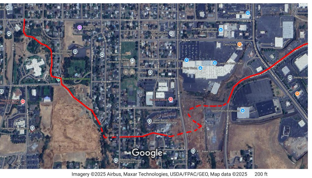
My job is in Lewiston, but I live in Clarkston, near Clarkston High School.It roughly takes about 15 minutes to get to work or come back home. For biking, I have a few routes that I could take to my job, which is near Home Depot in the Lewiston Orchards, but only one is relatively safe. Here’s a map with a few of the routes.
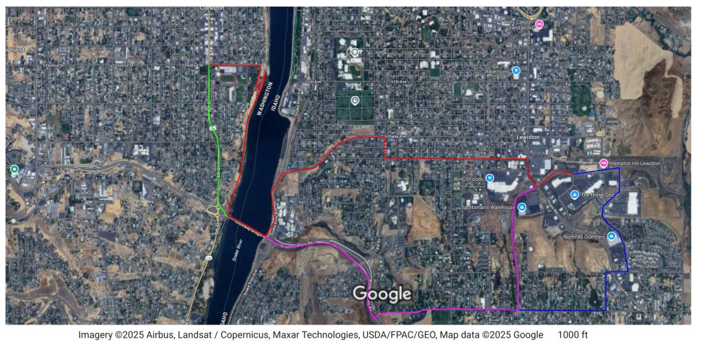
While Red, Green, and Purple are considered to be bicycle routes, only Red feels safe for the majority of the ride, since most of it takes place on a separated path specifically for bikes and pedestrians. Green feels unsafe due to being “bicycle gutters” alongside traffic that is supposed to be 35 MPH, but is commonly faster, Purple not only crosses traffic at that same speed, but then takes you up the very steep hill of Bryden Canyon, which is 45 MPH, but again people tend to ignore. I’m going to touch more on these routes in a bit, but let’s talk about the route I took to work: Red.
Getting There
The Red route took 26 minutes to complete near the middle of the day.
As I mentioned, Red started out comfortable. The Washington side of the path felt very comfortable; lots of trees and shade made it a very pleasant experience. Getting onto the bridge was slightly tricky due to lack of wayfinding signs, but I was able to get on with few problems.
Getting across the bridge on the North side is actually very comfortable, as there is a small wall that keeps bikes and pedestrians safe from the cars also crossing the bridge. The mile or so of pathway down Snake River Avenue is quaint, but does lack the trees and shade that the Washington side has.
Crossing the roundabout at Southway was slightly scary. I had a very nice car wave me through, but I think there are some improvements that could be made here that I want to talk about a little more in a bit.
I really liked the separated bike path along Southway, and was slightly disappointed when it ended just before Zips. Luckily the bike trail turns off a little afterwards and onto some side streets. The wayfinding on the Idaho side was very good, though did require a little improvement.
Crossing Thain/21st was scary, but I think doing the crossing on the North side of 19th was a lot better than the South side due to the amount of people who want to turn towards the Orchards. That said, the trip was basically uneventful after crossing Thain, and I was able to get to my destination without any further issues.
Getting Back
The Bl-urpl-een route took me 20 minutes to complete near midnight.
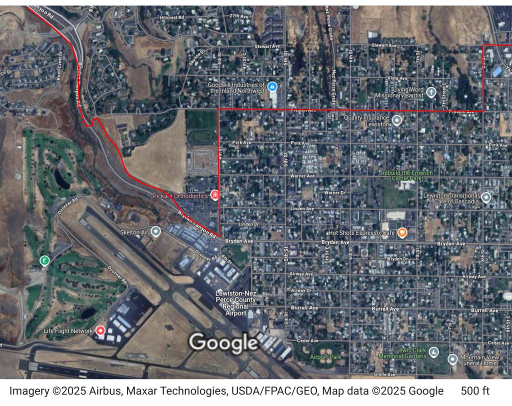
I ended up taking a combination of the Blue, Purple, and Green routes home. Due to lack of traffic, I felt comfortable taking Juniper Drive up to Preston, and then taking that to the bicycle route that travels down Bryden Canyon.
Now, the map above doesn’t truly show the official route that I took back. Instead, that looks more like this:
And this takes me into my next section.
Improvements
Clarkston
On the Clarkston side of things, better wayfinding would be helpful. Having some signs on the bike path that pointed to “North/South Side of Southway Bridge” would be very helpful.
I would also like the bike path along 5th Street (the Green route) to feel safer, potentially separated by something like Jersey barriers or metal posts. If that path felt safer, it could easily shave 5 minutes off the commute to work.
Lewiston
On the Idaho side of things… hoo boy.
More shade would be very nice along the dedicated bike paths. Trees take a long time to grow and can take up a lot of water, but even something like some shade netting on some poles would be better than the near 100 degree sun that we get in the summer.
The wayfinding was decent, but I wish there were a map underneath the wayfinding signs that could provide slightly more information. When trying to get to Home Depot, it was unclear if I should take the path to the Orchards or the Modi Conservancy, and a map or more clear wayfinding would have helped. Also, the trail turns onto 18th Ave from 7th St, but the paint markings on the road aren’t very clear and I ended up getting turned around after I realized that I actually did want to turn there.
The Bryden Canyon bike path does not feel safe to take for two reasons:
1. The concrete Jersey barriers are on the side of the chasm rather than the side with the 45+MPH vehicles
2. Crossing the slip lane at the bridge feels dicey when travelling into Lewiston
The first issue can be dealt with by adding a second line of jersey barriers. I’m not sure how to solve the second issue.
New Route Suggestions
This part of the article is about how to fix the routes by adding more routes or adding more to existing routes. I’ll start with cheapest to most expensive.
Preston Connection – $
You may notice that in the first image, the Purple route travels down Preston until it connects with the pedestrian bridge over Bryden Canyon. You may notice in the second image, the path I actually took was very roundabout, taking 4th Street up to the path that travels along Bryden and down to the pedestrian bridge.
I noticed that there seemed to be another connection to the path and I assumed it was connected to Preston, but since I had never been that far down Preston before I wasn’t sure. That next weekend I walked the path, only to discover that the connection was **not** to Preston, but rather to Mayfair Dr, a road that has absolutely no connection to Preston at all.
However, you can spot desire paths that connect Preston to the walking path, even in the Google Maps view.
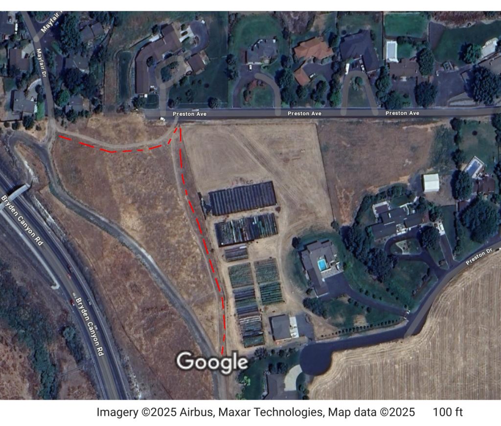
I think making these desire paths actually part of the walking path would help a lot, and could save at least 5 minutes of travel time in cases like mine.
Modie to Nez Perce Grade – $$
I mentioned that the bicycle paths are decent but could use more connection. This next idea may not exactly help my specific use-case but it would help bring more green to the area and provide more bike paths.
I believe it may be possible to slightly extend the Modie Park Conservancy path up to 24th Ave, where a bike path could extend across 15th St, down through a Cul-de-sac, and then across 5th St into an empty lot near Sparklight.
I believe the exiting empty lot, which is currently zoned Commercial that, to my knowledge, is not wanted, would work extremely well as a park with a bicycle and walking path that could connect to Nez Perce grade.
This could give some nice city-crossing alternatives to people who are not in cars, and would also provide another park for the residential area.
Pedestrian and Bike Bridge – $$$$
Neither the Blue Bridge nor the Southway Bridge are very comfortable to walk or cycle across. For the Blue Bridge, getting onto the bridge can be scary from all directions except from the marina, and the close proximity of the vehicles makes the experience not very desireable.
For the Southway Bridge, the South side of the bridge does not have separation from vehicles, and on the North side, you’re still really close to vehicles going 45+ MPH.
Due to this, I propose a Pedestrian and Bicycle bridge halfway between the two existing bridges connecting the Lewiston Levee with the Clarkston Waterfront path.
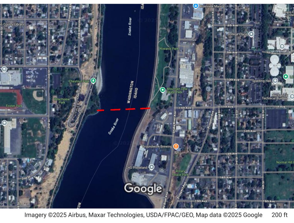
The proposed bridge would effectively connect Chestnut Beach with the Mountain Dew Skate Park, allowing for quick, safe, and easy connection for people who are unable to drive to get to major landmarks. It could also easily take another 5 minutes off of any potential bike commute, due to no longer needing to travel all the way to a bridge only to double back to Southway Ave.
The new proposed bridge may be spendy, but it has great potential to boost the economy and reduce the stress on our current bridge infrastructure. And seeing as how it wouldn’t need to accomodate cars, only bikes and pedestrians, it would be a lot cheaper than some other alternatives.
Conclusion
In short, I think there are a few ways that I could actually commute to work via an ebike in about the same amount of time as it would take to drive my car. Some of these are things I can do now that I’ve actually taken the bike, but there are many things that I would require from the city, state, or Army Corps of Engineers to complete.
Knowing what I know now, I think I may be able to get my commute home down to 15 minutes, but if I want to feel comfortable, my commute to work will have to stay around 20 minutes without some sort of major change that is out of my hands. Please improve cycling and walking in the Valley, our health depends on it.